Set for the Night [pic] http://ff.im/60R61
Monthly Archives: July 2009
Beating the #vancouver #heatwa…
Beating the #vancouver #heatwave and staying productive – all you need is a cooler and a comfy chair –> http://bit.ly/6GrO0
Beat the Heat and still be Pro…
Beat the Heat and still be Productive : Idea #304 [pic] http://ff.im/5Rdiq
Beat the Heat Idea #287 [pic] …
Beat the Heat Idea #287 [pic] http://ff.im/5Qh75
Low and Outside [pic] http://f…
Low and Outside [pic] http://ff.im/5JeCm
Oh No – It’s The Camera From H…
Oh No – It’s The Camera From Hell [pic] http://ff.im/5H4wL
Time it takes to cross Canada …
Time it takes to cross Canada by Via Rail: 10 days+delays. Time it takes to cross Canada when Via loco engineers are on strike: 5 hours.
Vancouver’s Dr. Tony Bates 1 o…
Vancouver’s Dr. Tony Bates 1 of 100 pilots flying across Canada to celebrate 100 yrs of flight – – http://bit.ly/5ngD8
100 Planes Fly Across the Country
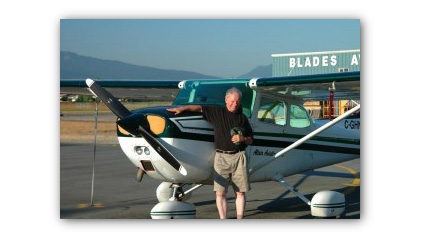
One of my clients, Dr. Tony Bates, is one of the 100 pilots flying across Canada to mark the 100th anniversary of flight in Canada.
Tony’s keeping a blog with details of his flight, which started on the July 17th from Boundary Bay airport. Except in Tony’s case, the flight started just a tiny bit sooner…
My plane ‘lives’ at Pitt Meadows Airport, just east of Vancouver, and a 10-15 minute flight to Boundary Bay. So why did I go to Tofino, 230 kilometres away on the far west coast of Vancouver Island, on my way to Boundary Bay?
Well, my plan has always been to fly the whole length of Canada, and any Canadian will tell you that the Trans-Canada highway starts in St. John’s, Newfoundland, and ends in Tofino. So let’s do the job properly!
You can follow his journey here. He’s already posted some great photos that capture what it’s like flying a small plane over a big country. (When he first told me about this project I didn’t have the nerve to tell him that I’ve always jumped out of Cessna 172’s like his, and rarely landed in one …)
Tony, by the way, is 70 years old.
And here’s the CBC.CA story on the flight.
Best of luck Tony !
Post Card Picture Perfect [pic…
Post Card Picture Perfect [pic] http://ff.im/5sdV1
Garden Golf Gnome [pic] http:/…
Garden Golf Gnome [pic] http://ff.im/5pHpv
Blue Finger [pic] http://ff.im…
Blue Finger [pic] http://ff.im/5pmY2
Luck with the Ladies [pic] htt…
Luck with the Ladies [pic] http://ff.im/5paXt
on mom nature’s grid for a few…
on mom nature’s grid for a few days: sun and wind power.
A panorama photo of the 2010 #…
A panorama photo of the 2010 #Vancouver #Olympics athletes village, under construction in southeast False Creek. http://bit.ly/v5WsJ
How the Olympic Athletes Will See Vancouver
During the 2010 Olympic Winter Games, the athletes village will be down at southeast False Creek.
If you haven’t been by there in a while, its worth a stroll along the water (start at Science World) where you’ll see the development from that aspect.
Yesterday I toured the area and got a bird’s eye view from the top of one of the buildings. (click this image for a larger version, or see this and another on Flickr)
This panorama is a series of six images shot handheld with a Nikon D70 and stitched using PTGui Pro.
More information on this whole area on the City of Vancouver’s website, Southeast False Creek.
Southeast False Creek & Athlet…
Southeast False Creek & Athletes Village [pic] http://ff.im/5c0XG
A trio of baby skunks outside …
A trio of baby skunks outside my bedroom (floor to ceiling) window. Interesting perspective – with me on the INSIDE and them looking IN.
madsu [pic] http://ff.im/58Ytx
madsu [pic] http://ff.im/58Ytx
Sea Grass [pic] http://ff.im/5…
Sea Grass [pic] http://ff.im/56sUb
Next to the Store [pic] http:/…
Next to the Store [pic] http://ff.im/54USp

